I agree to and consent to receive news, updates, and other communications by way of commercial electronic messages (including email) from ATEX Resources. I understand I may withdraw consent at any time by clicking the unsubscribe link contained in all emails from ATEX Resources.
The Valeriano Project is located within the roughly north-south trending Miocene to early Pliocene metallogenic belt that stretches along the eastern Chilean and western Argentinian border, continuing north into Peru (Sillitoe and Perelló, 2005). The Project is located within this metallogenic belt in an area situated between the northern limit of the El Indio Belt (Siddeley, G., and Araneda, R., 1990) and the southern margin of the Maricunga Belt. ATEX refers to this emerging trend between these belts as the “Link Belt” (Figure 1). Both the El Indio and Maricunga Belts host numerous significant copper and gold deposits and have seen extensive exploration since the 1900’s. The Link Belt has seen increased exploration since the early 2000’s leading to the discovery of several significant copper and gold deposits.
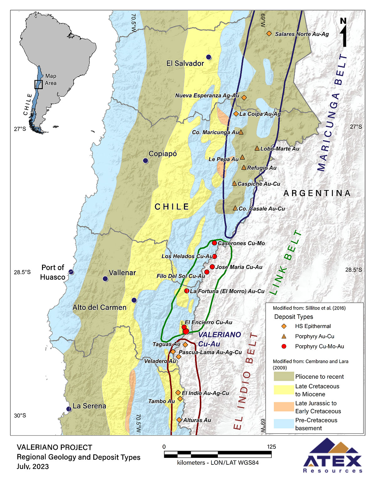
Figure 1. Regional Geology and Mineralization
The Valeriano Project (and adjacent El Encierro Project) occur within a north-south trending graben formed approximately 20 Ma ago during a period of major tectonism along the western edge of the continent. This resulted in the significant uplift of a Permo-Triassic aged package of rhyolitic to dacitic volcanic rocks which are underlain by a granitic Paleozoic batholith (Figure 2). This package was later intruded by a suite of granodioritic to dacitic porphyries during an extensive period of plutonism and volcanism occurring through the late Oligocene to late Miocene epochs. Finally, the upper portion of the package has been eroded resulting in the present-day landscape. The most prominent feature of the current Project landscape is a north-south trending ridge measuring roughly 18 kilometres in length and reaching an elevation of over 500 metres above the valley floors running along the east and the west of the ridge. Both the Valeriano and El Encierro Projects are located along the 18km north-south trending ridge.
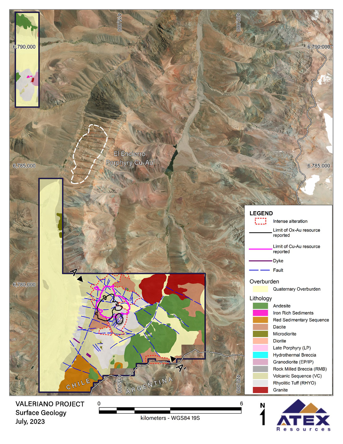
Figure 2. Project Geology
A large alteration zone can be seen along the 18km north-south trending ridge measuring in excess of 10 kilometres long, from the south of the Valeriano Project boundary to the northern extreme of the El Encierro Project boundary.
Three major phases of intrusion have been defined by ATEX geologists using data collected from drill core that details the temporal relationships between the various porphyry units. As each phase of porphyry is emplaced its attendant fluids are introduced into the host rocks causing them to be mineralized. As the system evolves, later phases of these fluids then remobilize and overprint pre existing mineralization as they advance. Collectively the porphyry units and the surrounding mineralized wall rock contain the most significant concentration of copper-gold mineralization within the project. Examples of these units are presented in Figure 3 and described in more detail below.
- Early Porphyries (“EP”) – The EP with a granodioritic composition is the oldest and best mineralized porphyry unit and is where the highest-grade copper-gold intersections occur. It is distinguished by having the most significant volume of quartz veining (up to 50%) included within it, with veins ranging in width from millimetre scale to multiple metres wide in place. The EP has been intersected in multiple drill holes across the project loosely defining three north-east trending, sub vertical, elongated bodies hosted within well mineralized RMB which are mineralized for to 700 m beyond its contact with the EP. The EP and adjacent mineralized wall rock surrounding each body is divided into three distinct trends namely the Western, Central and Eastern Trends.
These Trends have been intersected in drill holes covering an area with rough dimensions of one kilometre in length by one kilometre in width. The sizes of the three EP bodies range from a width of 100 metres in the Eastern Trend, up to 280 metres in width in the Central Trend and over 200 metres in the Western Trend. The length of the EP bodies, which have been constrained for modelling and estimation purposes, ranges from 700 metres in the Central and Western Trends to 300 metres in the Eastern Trend. The strike extent of the Trend’s has not been defined and remains open along strike to the northeast and southwest. The top of the EP as defined in drilling occurs at an elevation of 3,200 masl and has been tested to elevations of 2,140 and 2,250 masl with in the Western and Central Trends respectively, where it remains open.
- Inter-mineral Porphyries (“IP”) – These granodioritic porphyries occur with lesser quartz veining. They form relatively narrow, sub-vertical finger like features that strike north-east and are typically emplaced within and along structural features related to earlier phases of intrusives. By volume the IP constitutes a relatively minor component of the mineralized system, ranging in width from a few metres to tens of metres wide at their widest and having similar length constraints as the EP. It is less well mineralized than the EP units internally and mineralize wall rock that surrounds them.
- Late Porphyries (“LP”) – The late porphyries, also of a granodioritic composition, are the most recently emplaced units within the intrusive suite and have the largest vertical extent, occurring in outcrop at surface. Like the EP and IP units they are modelled striking northeast where they form along older reactivated structures and contacts. The LP typically appears massive and homogenous with little to no quartz veining and contributes the least percentage by volume to the mineralized system. When encountered they are typically a few metres to tens of metres wide and have lesser continuity along strike than the other intrusive units.
- Rock Milled Breccia (“RMB”) – The largest breccia unit on the Project is the Rock Milled Breccia “RMB” which is formed, enveloping the suite of porphyries and is mineralized for hundreds of metres outside of its contact with the porphyry. The RMB is silicified and mineralized by intrusive related fluids depositing chalcopyrite, pyrite, and other minor sulphide species with it. It is typically composed of poorly sorted clasts ranging significantly in size from a few centimetres to tens of metres and includes material derived from volcanic host rocks, intrusive units, and reworked quartz vein material indicating that the RMB has a prolonged formation history.
- Hydrothermal Breccias (“HBX”) – Also associated with the emplacement of the porphyries are a series of contact breccias which are composed of silicified fragments of host and porphyritic material in a hydrothermal matrix.
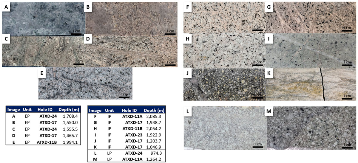
Figure 3. Mineralized Units
For further information, please see ATEX’s NI 43-101 compliant technical report titled “Independent Technical Report for the Valeriano Copper-Gold Project, Atacama Region, Chile” with an effective date of September 1, 2023, prepared for ATEX by SRK Consulting (Chile) SpA. A copy of the foregoing technical report is available on ATEX’s website and also under ATEX’s SEDAR+ profile at www.sedarplus.com.